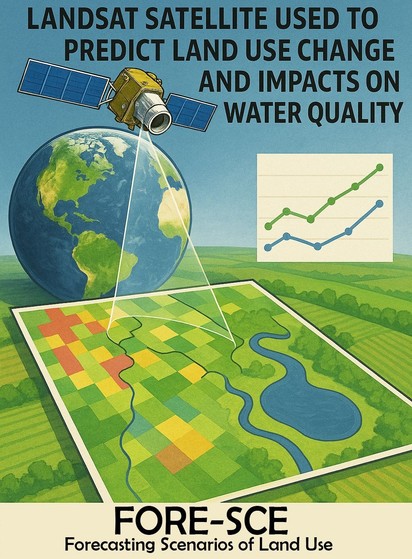
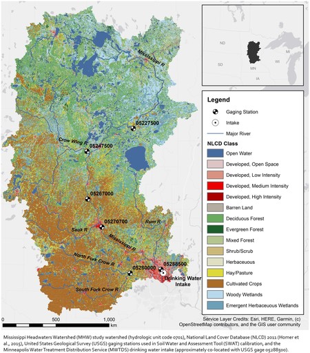
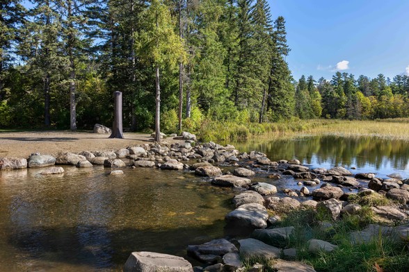
Modeling Future Land Cover And Water Quality Change In Minneapolis, MN, USA To Support Drinking Water Source Protection Decisions
--
https://doi.org/10.1111/1752-1688.13109 <-- shared paper
--
#GIS #spatial #mapping #remotesensing #earthobservation #landsat #fedscience #landuse #landcover #waterquality #model #modeling #spatialanalysis #spatiotemporal #NLCD #Minneapolis #MississippiR #water #hydrology #watersecurity #waterresources #nitrates #phosphorus #cyanotoxins #Minnesota #trees #agriculture #pesticides #fertiliser #farming #potable #runoff #farming #FORESCE #urbanisation #urban #headwater #watershed #planning #urbanplanning #management #nitrogencycle #soil #watertreatment #sediment
Recent searches
Search options
#landcover
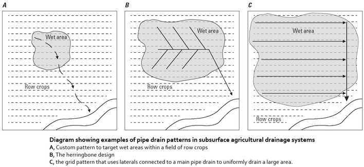
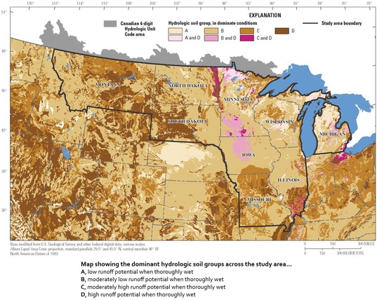
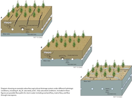
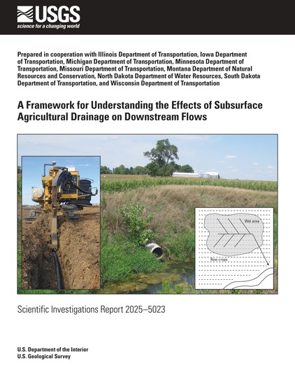
A Framework For Understanding The Effects Of Subsurface Agricultural Drainage On Downstream Flows
--
https://doi.org/10.3133/sir20255023 <-- shared USGS publication
--
#water #hydrology #mapping #framework #model #modeling #fedscience #streamflow #subsurface #soil #drainage #agriculture #farming #landuse #landcover #GIS #spatial #tiledrainage #drains #flow #waterresources #runoff #peakflow #evapotranspiration #precipitation #USA
@USGS
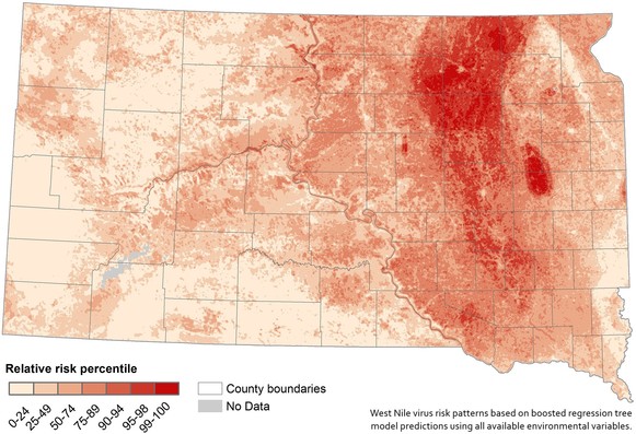
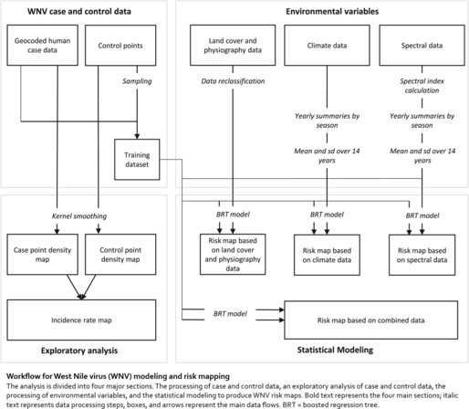
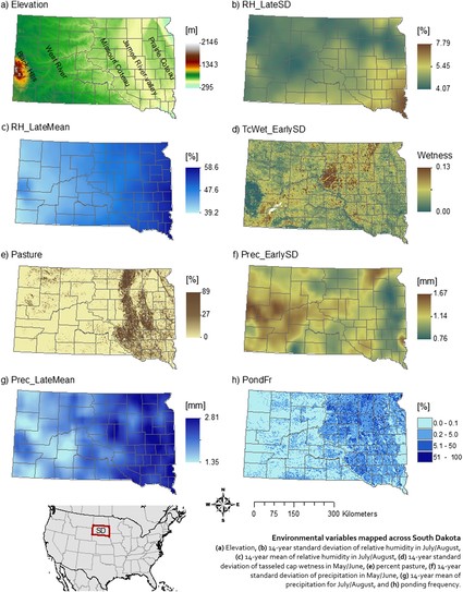
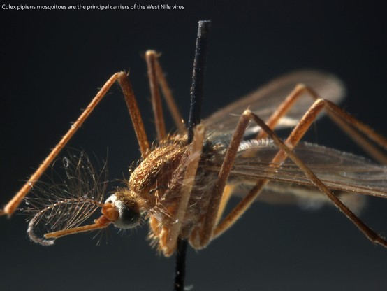
Identifying Environmental Risk Factors and Mapping the Distribution of West Nile Virus in an Endemic Region of North America
--
https://doi.org/10.1029/2018GH000161 <-- shared paper
--
[an older paper (2018) but a good one, including showing the versatility & usefulness of #FedScience spatial datasets]
#GIS #spatial #mapping #USA #WestNile #WestNileVirus #fedscience #NationalLandCoverDatabase #NLCD #virus #publichealth #arboviruses #environment #data #spatialanalysis #spatiotemporal #fedscience #geocoding #environmental #landcover #physiography #climate #weather #transmission #model #regressiontree #risk #hazard #riskmaps #elevation #humidity #rainfall #precipitation #disease #soil #integrated #opendata #mosquito #satellite #SouthDakota #pasturelands #crossdiscipline #virology #remotesensing #earthobservation #Pathobiology #Epidemiology
@USGS @USGS_EROS
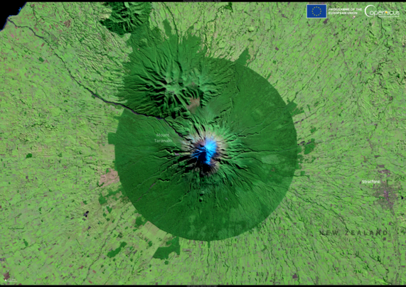
Mount Taranaki, New Zealand
#Agriculture #Land #LandMonitoring #Landcover
1 new picture from Copernicus https://commons.wikimedia.org/wiki/File:Mount_Taranaki%2C_New_Zealand_%28Copernicus_2025-04-14%29.png
Clear skies over the British Isles after a record-breaking March
#Atmosphere #ClimateChange #Landcover
1 new picture from Copernicus https://commons.wikimedia.org/wiki/File:Clear_skies_over_the_British_Isles_after_a_record-breaking_March_%28Copernicus_2025-04-05%29.png
The Ouarkziz crater, Algeria
1 new picture from Copernicus https://commons.wikimedia.org/wiki/File:The_Ouarkziz_crater%2C_Algeria_%28Copernicus_2025-04-03%29.png
Redu, Belgium
1 new picture from Copernicus https://commons.wikimedia.org/wiki/File:Redu%2C_Belgium_%28Copernicus_2025-03-30%29.png
Vipava Valley, Slovenia
1 new picture from Copernicus https://commons.wikimedia.org/wiki/File:Vipava_Valley%2C_Slovenia_%28Copernicus_2025-03-08%29.png
Valais, Switzerland
#HumanActivities #Land #LandMonitoring #Landcover #OtherHumanActivities
1 new picture from Copernicus https://commons.wikimedia.org/wiki/File:Valais%2C_Switzerland_%28Copernicus_2025-03-06%29.png
Dokkum, Netherlands
#Cities #ColdWaves #Land #Landcover
1 new picture from Copernicus https://commons.wikimedia.org/wiki/File:Dokkum%2C_Netherlands_%28Copernicus_2025-03-01%29.png
A Methodology For The Multitemporal Analysis Of Land Cover Changes And Urban Expansion Using Synthetic Aperture Radar (SAR) Imagery - A Case Study Of The Aburrá Valley In Colombia
--
https://doi.org/10.3390/rs17030554 <-- shared paper
--
#GIS #spatial #mapping #SyntheticApertureRadar #SAR #remotesensing #multitemporalanalysis #landcover #landcoverchange #clustering #kurtosis #fuzzylogic #kernelbasedmethod #machinelearning #spatialanalysis #spatiotemporal #geostatistics #model #modeling #AburráValley #Columbia #urban #urbanexpansion #population #growth #topography #monitoring #satellite #sentinel #valley #landuse #distribution #infrastructure #building #roads #naturalresources #environmental #conservation #monitoring #multitemporal
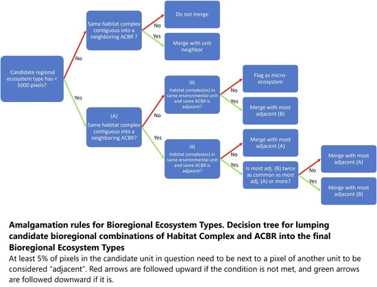
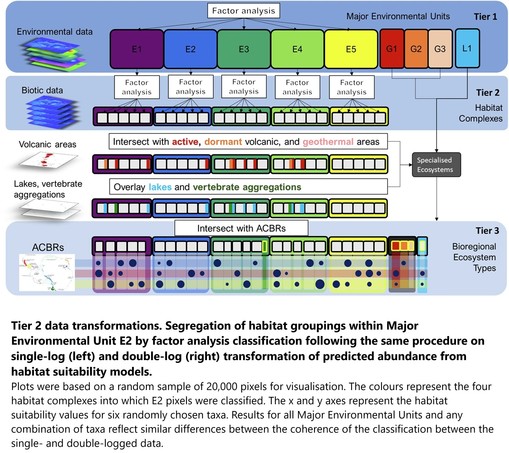
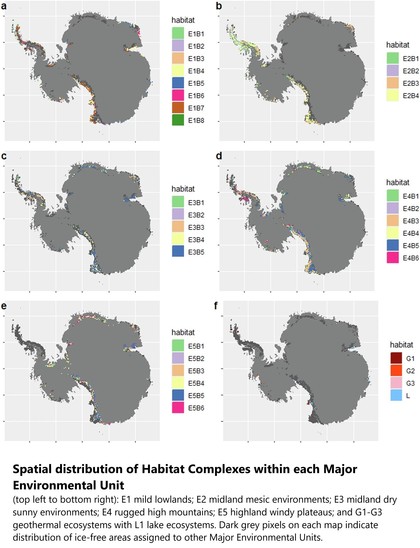
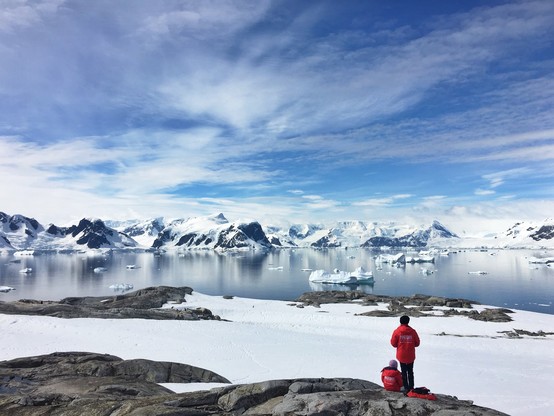
Mapping Antarctica's Hidden Ice-Free Lands - A Blueprint For Conservation
--
https://phys.org/news/2025-01-antarctica-hidden-ice-free-blueprint.html <-- shared technical article
--
https://doi.org/10.1038/s41597-025-04424-y <-- shared paper / spatial dataset
--
#GIS #spatial #inventory #mapping #Antarctic #ecosystems #wilderness #biodiversity #environmental #icefree #landcover #climatechange #humanimpacts #habitat #opendata #bioregional #abiotic #spatialmodel #biogeography #raster #model #modeling #spatialdata #futureproofing
Snowfall in Sierra Nevada, Spain
#Land #Landcover #NaturalEvents #Nature #SevereStorms
1 new picture from Copernicus https://commons.wikimedia.org/wiki/File:Snowfall_in_Sierra_Nevada%2C_Spain_%28Copernicus_2025-02-05%29.png
I have been digging out my old copies of John McPhee's #books, dipping in, remembering what it was like to be a new #geologist, and how it has carried across into #spatial #data, #geomorphology, #geomorphometry, #hydrology, #landcover, #engineeringgeology, #environmentalscience, #landuse, #massmovement and so much more......
This one paragraph reminded me so strongly of that time,, although I cannot of course write as eloquently:
--
"I used to sit in class and listen to the terms come floating down the room like paper airplanes. Geology was called a descriptive science, and with its pitted outwash plains and drowned rivers, its hanging tributaries and starved coastlines, it was nothing if not descriptive. It was a fountain of metaphor—of isostatic adjustments and degraded channels, of angular unconformities and shifting divides, of rootless mountains and bitter lakes..."
#GIS #JohnMcPhee #science #scientificwriting #readingforpleasure #geology #water #landforms #spatialanalysis #spatiotemporal
An Interagency Perspective On Improving Consistency And Transparency Of Land Use And Land Cover Mapping
--
https://doi.org/10.3133/cir1549 <-- shared USGS publication
--
#GIS #spatial #mapping #USA #nation #national #landcover #landuse #interagency #coast #coastal #change #remotesensing #satellite #risk #hazard #management #opendata #resources #vegetation #forest #agriculture #planning #climatechange #MRLCC #landchange #conservation #ecosystems #usecase #urbanplanning #water #watersecurity #foodsecurity #spatialanalysis #spatiotemporal #MultiResolutionLandCharacteristicsConsortium #federal #report
@USGS | @BLM | @USFS | @USFWS | @NOAA | @USDA
Snowfall in the Alps currently in line with historical averages
1 new picture from Copernicus https://commons.wikimedia.org/wiki/File:Snowfall_in_the_Alps_currently_in_line_with_historical_averages_%28Copernicus_2025-01-15%29.png
Parts of the British Isles covered with snow
#Atmosphere #Landcover #SevereStorms
1 new picture from Copernicus https://commons.wikimedia.org/wiki/File:Parts_of_the_British_Isles_covered_with_snow_%28Copernicus_2025-01-11%29.png
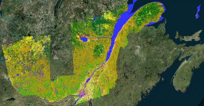
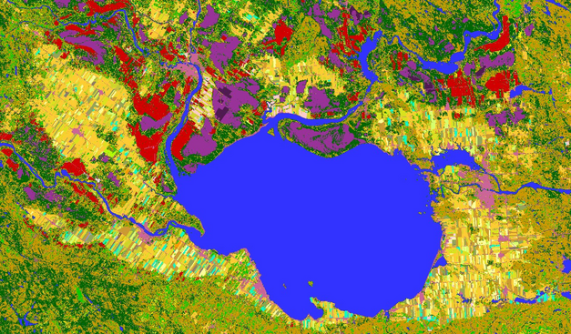
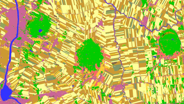
This week we released our 2024 Annual Crop Inventory for the Ag extent of
#Quebec.
https://open.canada.ca/data/en/dataset/ba2645d5-4458-414d-b196-6303ac06c1c9
Attached is an overview of it & a look at 2 areas all with alt text descriptions.
NOAA Digital Coast – Data Access Viewer [USA]
--
https://coast.noaa.gov/digitalcoast/tools/dav.html <-- shared link to viewer
--
[lots of new data added in the last 6 months]
“This online tool allows a user to search for and download lidar, imagery, and land cover data by user-defined geography. Once found, the data can be downloaded with an easy-to-use checkout interface. Users can select from multiple file formats, projections, and datums.
Features:
• View image services for applicable data
• View technical specifications and metadata for each data set
• Access data in several projections and datums…”
#GIS #spatial #mapping #spatialdata #opendata #LiDAR #imagery #NOAA #digitalcoast #USA #DataAccessViewer #landcover #topobathy #topography #bathymetry #charts #coast #coastal #CoastalChangeAnalysisProgram #CCAP #NLCD
@NOAA
Annual 30 Metre Maps Of Global Grassland Class And Extent (2000–2022) Based On Spatiotemporal Machine Learning
--
https://doi.org/10.1038/s41597-024-04139-6 <-- shared paper
--
https://landcarbonlab.org/insights/first-global-annual-cultivated-natural-grassland-data/ <-- blog post
--
https://developers.google.com/earth-engine/datasets/publisher/global-pasture-watch <-- Google EarthEngine
--
https://github.com/wri/global-pasture-watch <-- GitHub Repository
--
#GIS #spatial #mapping #workflow #global #grassland #shrubland #vegetation #spatialanalysis #AI #machinelearning #spatiotemporal #remotesensing #earthobservation #GLAD #landsat #imagery #opendata #landcover #agriculture #change #natural #model #modeling #pasture #cultivated #GlobalPastureWatch #grazing #livestock


