mas.to is one of the many independent Mastodon servers you can use to participate in the fediverse.
Hello! mas.to is a fast, up-to-date and fun Mastodon server.

Administered by:

Server stats:

12K
active users

#giscience

0 posts0 participants0 posts today

A quick illustrative #map on the implications of using different types of centroids in regional #demography #mobility and #migration studies.

Think about what you are emphasizing.

By using population-weighted centroids, you can emphasize the population perspective in the analysis instead of the geometry, potentially improving your analysis considerably. The distance difference is stronger in sparsely populated and remote regions.

I have struggled with many IDEs with their lack of good integration of interactive #Python.

VSCode and its derivatives are nice, but they do not play ball with my workflow. I can get what I want to work only partially, and it is much slower than my current workflow. Running one line at a time in an interactive window is excruciating.

Isn't it common in #DataScience and #GIScience to have an interactive workflow with a lot of back and forth reiterations with multiple line executions?

📣 We are #hiring!

We are looking for a GIScience researcher for a Postdoctoral Fellowship (6-12 months) on Climate Action, Open Geodata & VGI.

Are you a researcher with a passion for spatial data science and open geodata? Do you want to use your expertise about GHG emission inventories or active mobility to develop spatial indicators for Climate Action?

We look forward to receiving your application: heigit.org/job-posting/heigit-

Implementation of #BIM data in #CityGML—research and perspectives for creating a #QGIS plugin for spatial analysis: experience from Poland
mdpi.com/2071-1050/16/2/642
#GIScience

MDPIImplementation of BIM Data in CityGML—Research and Perspectives for Creating a QGIS Plugin for Spatial Analysis: Experience from PolandThe subject of this research was to develop an effective strategy for combining various data sources, including the feasibility of implementing BIM in CityGML into an existing system supported by the GIS program. The study analyzed the path for converting BIM files to the CityGML format and the course of transmission of this data and data from the completed queries to the GIS program. An overview of external sources, map services, tools for acquiring accurate information about the terrain, and IT tools that could potentially be used was also carried out. The collected data proved deficiencies in the geospatial information of the analyzed area, defining the type of missing data necessary for the planned analyses. The results made it possible to determine further work and the basis for developing a plugin for the QGIS program. The plugin should facilitate energy efficiency, urban, and architectural analyses. The article also discusses the future opportunities for developing research directions for developing new 3D models of cities and collecting data for analysis. The analyses took into account the directions of geometric changes in 3D models as the result of the rapid development of digital tools. Ultimately, this research demonstrated the development demand for modern digital tools in the context of spatial and urban analysis, emphasizing the dynamic evolution in the field of GIS and the prospects of accelerating work on the integration of spatial data and their analysis thanks to the possibility of using open-source programs and our own efforts for their expansion.

#QGIS based modeling and analysis of urban dynamics affecting land surface temperature towards climate hazards in coastal zones of Portugal
link.springer.com/article/10.1
#GIScience

SpringerLinkQGIS-based modeling and analysis of urban dynamics affecting land surface temperature towards climate hazards in coastal zones of Portugal - Natural HazardsClimate risk creates considerable concern due to the density of natural and socio-economic assets in coastal areas. Monitoring land use/cover changes, detecting population growth, and analyzing their impact on land surface temperature (LST) are necessary for effective urban management. In this study, land use/land cover (LULC), population, and LST changes in coastal regions of Portugal. Moderate Resolution Imaging Spectroradiometer (MODIS) satellite imagery was examined using World Bank population and CORINE data. Changes in land use types and LST values from 1990 to 2018 were analyzed. At the same time, LULC predictions were made using the Modules for Land Use Change Simulation (MOLUSCE) plug-in included in the QGIS software, and population projections were analyzed with LULC predictions in 2046. The results show the significant impact of land use on temperatures. It has been demonstrated that green and water areas can effectively cool cities. In the LULC changes between 1990 and 2018, the Leiria region stands out, with an annual increase of 4.04% in built areas from 121.58 to 259.06 km2. According to the simulations between 2018 and 2046, it was predicted that 18.74% of agricultural areas and 14.43% of forest areas would be transformed into built environments. The study is also essential as it confirms that the MOLUSCE plug-in can be effectively applied to land cover simulation on a large regional scale.

Has any of my #GIS #GIScience #paikkatieto colleagues bought the Finnish #SeutuData dataset? It is the "sequel" to the OG #SeutuCD data from past years.

I am thinking about the costs and resolution of the data. The original SeutuCD had population count level on the level of buildings, which we're after as we're looking at a current transport hot topic in #Helsinki and wonder whether we should acquire the data. The description of the newer data does not contain this information.

Hey #geography community on #Mastodon!

The 19th Conference on Location Based Services (LBS) will be held in Espoo, Finland from May 7th to 9th, 2025.

There are several topics in the conference ranging from big data analysis, ubiquitous positioning and context modelling to location privacy and digital humanities.

The call for papers is open!

Full paper DL 01.11.2024
Abstract DL 01.02.2025
Showcase DL 15.02.2025

lbs2025.lbsconference.org/

lbs2025.lbsconference.orgWelcome to LBS 2025 — LBS 2025

Hey, do you want to work in #research #science and have a knack for coordinating projects?

Become my colleague and come work at the @digigeolab at the University of Helsinki as a project coordinator.

Our research group is a talented and fun bunch of people doing research in #geography, #GIScience, #mobility, and #conservation.

Deadline for applications is next sunday, so apply fast if you're interested!

jobs.helsinki.fi/job/Helsinki-

jobs.helsinki.fiResearch Coordinator / Project PlannerResearch Coordinator / Project Planner
#work#job#työ

Excited to go to #MobileTartu to present the things we've been up to in @digigeolab when it comes to regional mobility.

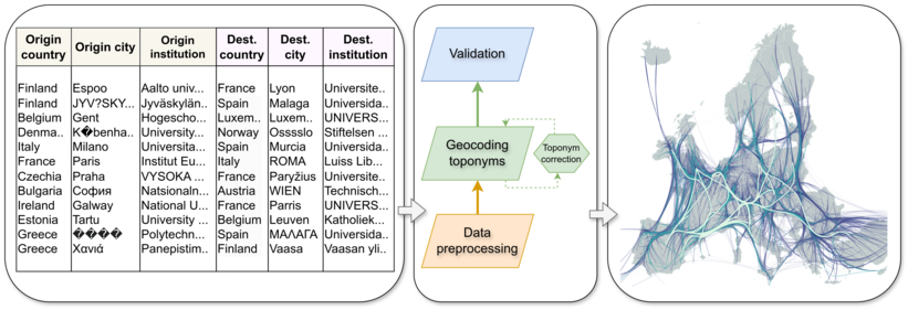
I'm presenting our on-going work examining changes in long-distance commuting in Europe during 2012-2022 using big social media and Labour Force Survey data.

Still some figures need to be finalized, but I am looking forward to the conference. Anybody else from the fedi #geography #giscience and #geospatial community in #MobileTartu2024?

Continued thread

And most recently in #Geopraphy:

Van Deursen, J., Creany, N., Smith, B., Freimund, W., Avgar, T., & Monz, C. A. (2024). Recreation specialization: Resource selection functions as a predictive tool for #ProtectedArea #RecreationManagement. Applied Geography, 167, 103276. - "#GeoPandas and #MovingPandas packages in #Python were used to analyze the GPS data collected and calculate the thirteen spatio-temporal metrics"

sciencedirect.com/science/arti

Wow! 🥳🎊 I received a copy of a book we wrote a chapter for with @tuomo and Hanna-Mari Pienimäki.

It's one thing to see one's own work published on a website, but another feeling when you can hold it in your hand.

If you're interested in #multilingualism #sociolinguistics #UrbanStudies and #LinguisticLandscapes check out this book. Relevant also for #UrbanGeography #HumanGeography #GIScience and #multimodality 🤓

The #OpenAccess book is available here: oa.finlit.fi/site/books/e/10.2